
2003: Florence Lake to Italy Pass Loop
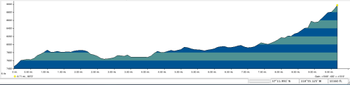
Florence Lake to Italy Pass Loop (45.5 miles)
Mid August 2003
Nick and Charlie


Day 1: Florence Lake to Puite Canyon (10 miles)
Day 2: Piute Canyon to Honeymoom Lake (10 miles)
Day 3: Day Hike
Day 4: Honeymoon Lake to Lake Italy (5 miles)
Day 5: Lake Italy to Marie Lakes (9 miles)
Day 6: Marie Lakes to Blaney Meadow (7.5 miles)
Day 7: Blaney to Florence Lake (4)
The buddy I had been hiking with for years no longer was up to backpacking, so I needed a new partner. I ended up finding a partner for this hike through Craig’s List. So, this Charlie is not to be confused with the Charlie from my 1994 trip.
————
Day 1: Florence Lake to Puite Canyon (10 miles)
7,400′ – 9,000′
We took the 8:30am boat across Florence Lake. We left the lake at 9:00 am. Took South Fork Trail.

Charlie and Nick at trail head
Started out at 7,400′ with about 600′ climb to start, then some up and down, until turn off into Piute. This part was mostly semi woodsy and gradual climb, some ups and downs.

View from Blaney Meadow
We headed left (east) up Piute Canyon with about 1,000′ climb to reach 9,000′.
At 2:00ish stopped for a lunch break. The trail is mostly above the creek, so only sporadic water access.

Nick at Campsite along the Piute trail
4:30 We camped up high a few miles along the Piute Canyon Trail. We should have gone a bit further and camped lower, but did not see a lot of great camping along here.
Day 2: Piute Canyon to Honeymoon Lake (10 miles)
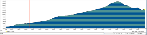
9,000′ – 11,200′ – 10,400′
At 9:00 we left camp.

Nick along the Piute River
10:00 We took an early break at junction of Hutchkin’s meadow. From there we continued northeast up French Canyon. French Canyon was mostly open meadow.

Nick at Pine Creek Pass
Most of the hiking is a gradual climb to about 11,000, and then a slight drop down to the lake. We camped above (west) of lake, just off the trail, at about 6:30.

Honeymoon Lake camp
Honeymoon Lake was very pretty, with a fair number of campers scattered around it, though we had privacy where we were, though not easy access to the lake.
Day 3: Day hike to Royce’s lakes
This was out rest day, and we took a nice cross-country hike up to Royce’s Lake.

Royce Lake
It was very quite gorgeous, but exposed and when we were up there it was very windy and cool. In hindsight, we could have come to Honeymoon following a cross-country route up these high lakes from from Piute paralleling the valley. I think it would have been more interesting.
Day 4: Honeymoon to Lake Italy (5 miles)
10,400′ – 12,400′ – 11,200′
At 9:15 we left camp. It was a steady climb from 10,500′ to the pass at almost 12,500′

Waterfall
At noon we got to the last lake before Italy pass and had a very nice swim there.
At 1:25 We started up to pass, a good steady climb with a clear trail.

Charlie at Italy Pass

- Nick at Italy Pass

At 2:00 we arrived at Italy pass, and had a nice snack break.
2:30 We left the pass. The path stays to the north of the bowl and is well above Jumble Lake. Much of the trial is just sand and scree.
At 4:30 we arrived at Lake Italy. We found a somewhat developed site up by rocks to the east of the inlet. Italy lake is quite barren, and was quite windy, which while somewhat annoying does help keep the mosquitoes down a bit.
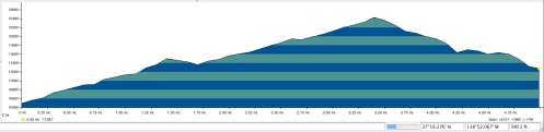
Day 5: Lake Italy to Marie Lakes (9 miles)

11,200′ – 9,400′ – 10,600′
9:30 We left Lake Italy
It took 50 minutes to traverse the lake, along the south shore. Then heading down the Hilgard branch, the use trail was hard to follow for first half-way.

We had to ford the stream at some point, but were not along any particular trail when we did. It got sluggish hiking at points through and over dead branches and growth. It was very buggy in the valley—black biting flies for which deet had absolutely no effect. Once one leaves the lake it is a steady drop down to about 9,400′.

Charile along the Hilgard
At the JMT we headed south up the trial. Had planned to take the trail to Saddlerock lake but missed the turnoff. We went straight on to Marie Lakes instead,. The Marie Lakes are quite nice, though since they are on the JMT, there are always quite a few people there.
We arrived at Marie Lake (10,500′) at about 5:00pm.
Day 6: Marie Lakes to Blaney Meadow (7 ½ miles)

10,500′ – 10,900′ – 7,700′
I had planned on spending a rest day there, but Charlie wanted to move on. Instead we agreed that I would do a side trip up a peak, and then we’d leave around midday.

Marie Lake
9:00 I did the southern peak on other side of Marie lakes, while Charlie stayed behind. It took me 2 hours to go up. One can go over that way to the lakes on east side. It is exhilarating going up. Tried to traverse to northern peak of ridge (11,700′), but couldn’t find a way down that side of southern peak. Came back down and continued around lake. Arrived back at camp at 12:30. Charlie was tired of waiting so he took off. I stayed to eat lunch and we agreed to meet up at Sally Keys. After lunch I took a brief dip in a “swimming hole.”

Nick hiked to this peak
I couldn’t get into my boots due to blisters on my toes, so I wore my Teva’s to hike in. I arrived at a little after 2:00 at Sally Keys—hiking extremely fast. Bob insisted we go all the way to Blarney meadows instead of stopping at river as we had planned. It was just as well, as area was biting black fly infested. The first half has very little elevation gain or less, with then steep drop with switchbacks down to about 7,800′.
5:30 We arrived at Blarney Springs. We set up camp and took a soak and swim and soak. You have to cross very fast moving river to get to the hot springs. Springs are off to the right in back of field. There is a great swimming pond of warmish water 50 feet behind the hot springs in the woods.
Day 7: Blaney to Florence Lake (4 miles)

7,700 – 7,900′ – 7,400′
Hiked back out the few miles to Florence lake and took ferry back to car.

Nick back at Florence Lake
To see the full set of pictures from this hike you can link here to my Flickr album.
