
2009: Wolverton to (almost) Triple Divide loop
Trip Report for Wolverton to (almost) Triple Divide loop (32 miles)
July 16–20, 2009
Nick, Shahe, Kevin


Day 1: Wolverton to Moose Lake (8 miles) (part cross country)
Day 2: Moose Lake to Lonely Lake (4 miles) (cross country)
Day 3: Lonely Lake to Tamarack Lake (5 miles) (cross country)
Day 4: Rest Day at Tamarack Lake
Day 5: Tamarack Lake to Wolverton: (15 miles)
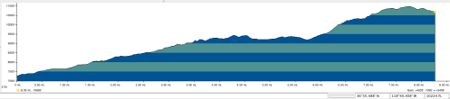
I took this trip with my hiking buddies Shahe and Kevin. We did a mostly cross-country Loop leaving out of the Wolverton trailhead near Lodgepole. After driving from Santa Cruz that morning, we did not get on the trail until about 2pm.
—
Day 1: Wolverton to Moose Lake (8 miles) (part cross country)
7,200′ – 10,800′
We took the trail to Pear Lake where the trail ended (about 7 miles). We considered stopping as it was 4:30 by the time we got to the lake. While beautiful, there were quite a few people there, so we decided to push on to Moose Lake, another 2 miles of cross country hiking.

Nick, Shahe and Kevin on way to Pear Lake
The Trail to Pear Lake was mostly wooded and wonderful views along the way especially as we gained altitude, but all that uphill on the first day is tiring. At Pear Lake we got route advice from a ranger there, which contradicted the advice from the ranger at the Ranger Station in Wolverton. Following the advice of the latter, back country ranger, we headed basically directly east to get from Pear Lake to Moose Lake. Moose Lake was barren, but lovely, though it was nearing sunset when we arrived. Altogether we gained about 3,500 feet that day.

Arriving at Moose lake
Day 2: Moose Lake to Lonely Lake (4 miles) (cross country)

10,700′ – 10, 300′ – 10,900′ – 10,400′ – 11,400′ – 10,900′

Fish for breakfast
The next day we had planned on getting all the way to Lion Lake, but that turned out to be overly ambitious. Also my partners insisted on heading in a direct line from Moose Lake toward Lonely Lake, which meant a lot more up and down than if we had skirted a bit to the north, as I had planned.

Nick hiking
We had a little trouble finding Lonely Lake, as it was hidden, but finally figured out our route. But when we got to the ridge past Lonely overlooking Kings Canyon, the weather was getting nasty, and though it was only 3:00, we had only open ridges ahead of us, so we camped by the aptly named Lonely Lake. It was only about four plus miles of hiking, but lots of up and down, and we spent quite a bit of it arguing over where we were and the best route. Luckily the rain was light and only lasted until early evening.

Playing cards at Lonely Lake
Day 3: Lonely Lake to Tamarack Lake (5 miles) (cross country)
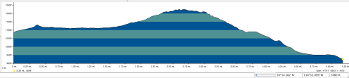
10,900′ – 12,300′ – 9,300′

Shahe at the Ridge on way to Elizabeth Pass
The next day we headed down into the bowl just north of Elizabeth Pass and then up to Cooper Mine pass, which was snow and scree all the way up. At the top we were right on the ridge, looking for the best way to drop down all the steep scree into Lion Lake. We had planned on going to Lion Lake, and then up the drainage to the next lake above it and over the pass there and down into Nine Lakes Basin. However, it started to rain with lightening and thunder, so we figured we had better get off the ridge ASAP. After a bit of arguing, we went straight down the steep scree to the outlet stream from Lion. We were unsure about doing the pass above Lion. From the views we had it looked quite snow covered, and our information on how to approach it was almost non-existent, so we then decided to head down to Tamarack Lake, rather then up to Lion Lake. (Later we were told we probably took the more difficult route).

Copper Mine Pass with view of Lion Lake
When we got toe the outlet stream from Lion, we took a rest. After our rest, we first tried the north side of the stream after the falls, but got stuck, and had to retrace our steps. We crossed the stream at the falls and then headed down pretty much following the stream. When we got to the meadow, and crossed it to the lake, we saw the lake was still at least 100 feet drop below us. We stayed to the north of the lake, and after a bit of floundering, finally found a place to slide down just to the west of the lake to get down to it. It was only 5 miles of hiking according to my Topo, but that was a long hard day of hiking!

Nick at Falls on way to Tamarack
Tamarack was gorgeous and we had it to ourselves on that weekend, spending a rest day there. The trout were most abundant and a nice addition to our camp meals. Also some wild onion added some spice to our meals as well. While we did see bear claw marks that looked recent, we never did see the bear.

Tamarack Lake
Day 5: Tamarack Lake to Wolverton: (15 miles)

9,300′ – 8,000′ – 8,600′ – 7,300′ – 9,100′ – 7,200′
The following day we headed out the trail for the a long hike out down Lone Pine Meadow, past Bearpaw Meadow Camp and back out to Wolverton (over 15 miles). We went from over 9,000′ down to 7,000′, back up to 9,000′ and then back down to around 7,000′ again.

Shahe and Kevin hiking in the field
All in all though, it was what we were looking for—solitude, great high country views, some challenges, nice lakes and great hiking, and a loop trial.
To see the full set of pictures from this hike you can link here to my Flickr album
