2015: Hoover Wilderness / Yosemite
Hoover Wilderness / Yosemite: Twin Lakes to Benson Lake Loop (clockwise)
(≈52 miles)
Nick, Jonathan, Kevin
August 9-14
This was a MeetUp hike organized by Jonathan
We left on Saturday afternoon meeting at Jonathan’s to carpool. I had had a tennis match earlier that day in Monterey that ended up being a tight three setter, so was glad someone else was driving. We car camped on the other side of the Sonora Pass at the Obsidian Campground. We were going to stop at an earlier one, but it was full. This one is a bit of a drive back into the woods, but there is no fee. We got in there quite late, in the dark, and at first had a hard time finding the actual camp spots as there is no signage.
In the morning we had breakfast at the Bridgeport Inn—a nice quaint place—then off to pick up our permits at the ranger station and off to Twin Lakes.
Twin Lakes is a private RV campground and boating area, but they also provide (for a fee) trailhead parking.
Day 1: Twin Lakes to Crown Lake (9 miles)
Day 2: Crown Lake to trail junction Matterhorn Canyon (13 miles)
Day 3: Matterhorn Canyon to Benson Lake (11 miles)
Day 4: Benson Lake to Peeler Lake (10 miles)
Day 5: Peeler Lake to Twin Lakes (9 miles)


While some descriptions of this trip suggest going counterclockwise, I suggest the way we did it, clockwise, as it puts the climbs in the beginning of each days journey. The only possible advantage of going counter that I see is that it makes day 2 relatively easy, with very little climbing at all. but on the other days, it puts some significant climbs toward the end of the day.
Day 1: Twin Lakes to Crown Lake (9 miles)


7,100′ – 9,500′
We left the car at about 9:45am. First there is about a half mile walk though the RV park to get to the actual trailhead.
 The trail starts out fairly flat heading up through meadow and some areas of aspens.

Jonathan on trail
After a while it starts to head up into the mountains themselves. About four miles in there is the first lake, Barney Lake. It has a nice shallow beach at the north end where you first encounter it. There is camping just back of the beach in the woods. We had a brief snack there before heading on.

Nick at Barney Lake
There were groups of people there—some tossing sticks into the water for their dogs to chase—as it is a popular day hike form the campground. After leaving the lake, the trail gets a little steeper as it heads into the canyon, but mostly the climb is gradual.
We arrived at Crown Lake at about 3:00pm

Crown Lake
We were worried there would be a lot of people camped at Crown, but we found a nice spot with no one near us on the far end of Crown. Just as you get to a rock, leave the trail and cross the little inlet where there is a little use trail leading a great place to campsite up against the rock outcropping. The other people camped at the lake were on the other side, which actually looks to be a bit tricky to access. I did take a nice dip in the lake.
Day 2: Crown Lake to trail junction Matterhorn Canyon (13 miles)

9,500′ – 10,500′ – 9,400′ – 10,600′ – 8,600′
We got started around 8:00am. The trail heads up to the first pass pretty much right away. There are several places you might think you are at the pass, but not yet.

Nick at Tarn below Mule Pass
There is a nice tarn with good camping just a couple hundred feet below Mule Pass. We got to mule pass a little past 9:00am. This is also where you cross over from Hoover Wilderness into Yosemite.

From Mule Pass you descent fairly quickly at first. Then it’s a steady, mostly gradual climb back up to Burro Pass. We got there just past noon and had lunch there.

View from Burro Pass
Then there is a quick descent down to the meadow and after that fairly flat following near the creek. We did not see much in the way of camping along the creek, though there may have been spots on the other side. The first good camping we found was just past the junction at the river crossing. There is a decent spot to the left of the trail just before crossing, and some excellent camping just across the river, where we camped. We arrived there at about 3:30pm.

Camp at Matterhorn Creek
I did not see any good swimming or fishing spots, though have read that there are some. Maybe it was just really low this year with the drought.
Day 3: Matterhorn Canyon to Benson Lake (11 miles)


8,500′ – 10,200′ – 9,200′ – 9,500′ – 7,600′
We got started around 8:00am. After following the river downstream for a little, the trail then cuts to the right up the gorge where the ascent begins. There are periods of steep climb and then leveling off, through woods and meadow.
We got to Benson Pass at around 10:15am and had a nice break there. There were several others up there as well. From there we headed down.

We got down to Smedberg Lake at about 11:45am. We had a nice lunch there and I had a dip in the lake. If we had more time we might have explored some of the other lakes to the north.

Nick Diving in Smedberg Lake
Then more downhill, but as we did so at one point we lost the trail. After trying going down for a bit to find it, I finally decided to head to the left, as the map showed the trail veering off that way, and we did reunite with the trail. It turns out the trail goes back up and over a knoll, gaining several hundred feet, instead of going right down the gorge. Then continues down and down and down until finally reaching the turn to Benson Lake.
Benson Lake has a nice long and wide sandy beach. The water is relatively warm as mountain lakes go. However, there is little else there besides the beach, as the shore is impassable on the other sides, and behind the sandy area it gets a little marshy.

Benson Lake
There was a Conservation Core group camped there—a bit rowdy in the evening, and then pretty noisy as they got up in the morning as well. But they had quieted down by the time we went to bed, and we were up as early as they were.
Day 4: Benson Lake to Peeler Lake (10 miles)


8,600′ – 9,100′ – 8,900′ – 9,600′
We again left around 8:00am. From Benson it is an early steep climb with lots of rock stairs. Along with way we passed a lot of the CC workers working on the trail.

Heading up to Buckeye Pass
They work hard! It is on and off steep climbing up the trail, but once you get to the top, there is not really and identifiable pass, as it levels out. There is a bit of a drop soon after the “pass.”

Unnamed lake
Then there is a nice stretch through woods and by some lakes and along the Rancheria River.

After that it becomes long open flat meadow.

Nick
Before getting to the lake the trail to Peeler Lake goes off to the right as it goes into the woods.
We arrived at the lake around 2:00pm. When we arrived at the lake, we debated whether to look for camping on that end or go further where Jonathan knew there was a bigger campground near the water. He was afraid it might be full of people, so first we looked on the west side. We did not see anything we liked, but did see at least one group caped over there.

Peeler Lake
We went on and found the large campground on the north side. We ended up having this beautiful campsite, with a nice little beach, to ourselves.
We all ended up taking a dip here.
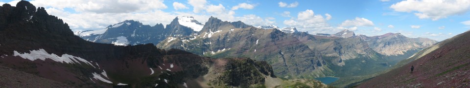
Day 5: Peeler Lake to Twin Lakes (9 miles)

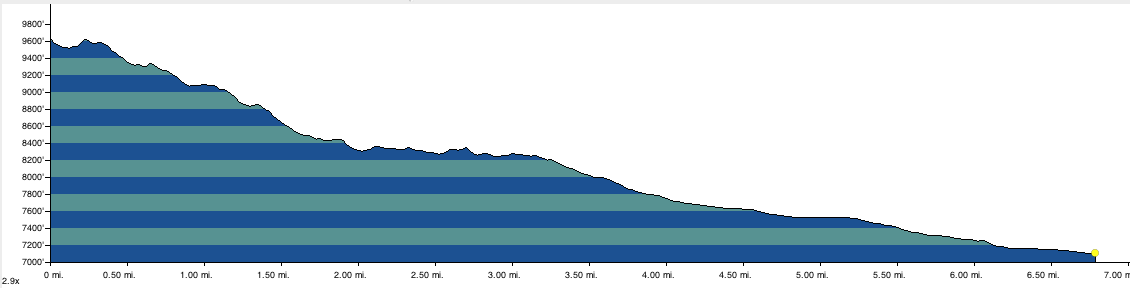
9,500′ – 7,100′
We got a little bit earlier start on our last day out, getting on the trail by 7:30.

Stream Crossing
We kept up a good pace, as the trail is almost all downhill from Peeler Lake back to Twin Lakes.

Barney Lake
We took a brief snack break at Barney Lake again, as it is about the halfway point. We arrived back at the car close to 11:00am.

We Made It!
To see more of my photos from this trip click here

doing this same loop in August, are there any days where you are above the tree line? is hammock camping viable on this loop?
My memory is that none of the camping would have been above tree line. Whether hammock camping is viable I could not say. Since none of us did that, I was not looking at sites with that view in mind. If you click on the link to see my full photo album from the trip on Flickr you can get a better sense of the spots where we camped.