
2011: Mineral King–Franklin–Sawtooth Loop
Mineral King –Franklin–Sawtooth Loop (28 Miles)
August 8 to 13, 2011
Nick, Shahe, and Ted

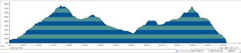
Day 1: Mineral King Trail Head to Franklin Lake (5 miles)
Day 2: Franklin Lake to Little Claire lake (6.4 miles)
Day 3: Little Claire Lake to Lake 10,100: (7 miles)
Day 4: Day hike to Little Five Lakes.
Day 5: Lake 10,100 to Monarch Lake: (6.7 mile)
Day 6: Monarch Lake to Mineral King: (3.5 miles)
——–
Day 1: Mineral King Trail Head to Franklin Lake
7,800′ – 10,600”

Shahe and Nick at Trailhead parking
We left the Trail Head a little after midday at an altitude of about 7,800′. The trail was a fairly steady climb the whole way to the lake at about 10,500′. Franklin Lake was nice, though there were a fair umber of campers there, as to be expected from a lake that is only 5 miles from a trailhead.

Waterfall along route
While there are many nice camping spots, ours was reasonable, but given we got there later, our spot was not one of the better one’s and was a little ways up above the lake itself with others campers very close by. The best sites were those at the outlet of the lake as one comes up the trail.

Campsite at Franklin

Sunset at Franklin
Day 2: Franklin Lake to Little Claire lake: 6.4 miles

10,600′ – 11,800′ – 10,200′ – 10,800′ – 10,400′

Upper Franklin Lake
We started reasonably early in the day, and took a short side trip to the upper Franklin Lake which provided some nice views.

Nick heading down from Franklin Pass
From there we headed back to the trail and up to Franklin Pass for a climb of 1,400′ (pass at 11,900′), then dropping back down to 10,200′ and some up and down to Clair Lake at 10,500′.

Forester Lake
We took a rest stop along the way at Forester Lake, which was a tempting place to actually camp, but then headed on to Little Claire Lake, where we camped near the outlet.

Shahe Plays the Flute
This was a lovely spot just above where one drops down into the valley. Unluckily none of us fish, as this is probably a good lake for some small trout.
Day 3: Little Claire Lake to Lake 10,100: 7 miles
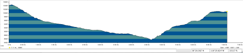
10,400′ – 8,600′ – 10,200′

View down Soda Creek from Little Clair Lake
Leaving Little Claire, heading mostly north, we dropped straight down, descending about 1,000′ in less than a mile, and then dropping another 1,000′ as we headed down Soda Creek.

Shahe fording Soda Creek
We had to ford Soda creek, an easy ford, at the bottom.
After a couple of miles we then headed west up into Lost Creek Canyon. About a mile and a half up the trail, rather than continue up the canyon, we took the trail that leads north over to Big Five Lakes and stopped to camp at an unnamed lake near the “pass.” This took us back up to 10,100′. The mosquitoes were particularly bad there, and we camped up a slope on the northern side of the lake in a woodsy area, a little ways form the lake (which was marshy on the south side). We were hoping to be away from the worst of the mosquitoes, though they were still bad.
Day 4: Day hike to Little Five Lakes.

View above the unnamed lake
We took a rest day here and did a side hike to explore the Big 5 Lakes. There was quite a bit of up and down. The lakes were beautiful, but the mosquitoes were out in full force pretty much all the time. I had found that true during a previous trip to those lakes a few years back as well. Maybe my timing was just unfortunate both trips (and this had been a particularly wet winter with a heavy snowy pack).

Nick takes a dip
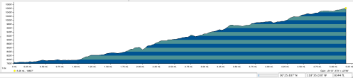
Day 5: Lake 10,100 to Monarch Lake: 6.7 miles
10,100′ – 9,600′ – 11,700′ – 10,400′
We started out planning on stopping at Columbine Lake to camp before heading over Sawtooth, which has a reputation as begin difficult. We also knew, though, that there would not be that much good camping at Columbine, and had run into several large parties that were also planning to camp there that night.
We first dropped back down from the lake to Lost Canyon for about a 500′ descent. Then we headed back up Lost Creek, having to ford it.

Nick, Ted, Shahe at Columbine Lake
We headed gradually up the creek until getting to the base in order to head up to the pass. Heading up was steep with some snow and a bit of scree, finally arriving at Columbine. There was a small Boy Scout group that was also going up as we did and some others already camped there. We took our lunch break there, and as it was still just midday, we decided we would head on over Sawtooth Pass and camp down at Monarch Lake.

Hiking up to Sawtooth
The way up to the pass had some snow fields, but we were able to mostly skirt them, and while steep, it was not difficult, reaching the pass of 11,700′.

View down Sawtooth
The way down Sawtooth was all steep sandy scree. While there were various “paths” that led down, it did not really matter which one took. After a steep descent of about 1,300′ we headed over to Monarch Lake, a lovely spot where we caught a beautiful simultaneous sunset–moonrise. Being only a few miles from the trail head, it too was fairly populated with campers, though we were able to find a space with some privacy. There was even an outhouse. At dusk there was a deer that was quite bold prowling through the campsites.
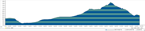
Day 6: Monarch Lake to Mineral King: 3.5 miles

10,400′ – 7,800′

Looking down toward Monarch Creek Canyon
There was one tricky spot crossing some snow on the path, but otherwise basically a descent down 2,600′ back to and elevation of 7,800′.

Back at the car safe and sound
We arrived back midday to the car, ready for the long drive home, not too much worse for the wear.
All in all a wonderful trip.
To see the full set of pictures from this hike you can link here to my Flickr album.

Nick – Thanks so much for posting this! A college buddy and I just finished this loop, less the day hike to Little Five Lakes. Most of our planning was based on your post.
We also stopped at lower Franklin Lake for our first night, camping on the rocky shore across the dam. We followed your footsteps over Franklin Pass and swam at Forester Lake before camping on the sandy shore of Little Claire Lake. On our third night, we camped alongside Lost Creek just beyond the Five Lakes trail junction. Our fourth day took us to Columbine Lake and over Sawtooth Pass. Unfortunately the weather took a turn for the worse and the rain, wind, and hail that greeted us atop the pass convinced us to bypass a night of camping at Monarch Lake and head all the way out instead, giving us beds to sleep on and a bonus day exploring the big trees in the northern part of the park.
Due to the dry winter, we didn’t encounter any snow and were able to walk across the rocks instead of fording the creeks. And the descent from Sawtooth Pass was a bit dicey, as we lost the trail for a bit before some boulder scrambling got us back on track!
All in all a great hike. Thanks for the inspiration!
-Jeff